Fourteen Days
When I was eleven years old, my step dad Henry took me hiking up Mt. Hesperus in the La Plata range near Durango, Colorado. It was July 4, 1986. Even on that first hike, we took a bad gully on the way down, and Henry had to help me down some icy, rocky ledges. When we got out of the gully, I slipped and fell all the way down the snowfield.
That hike inspired Henry, and he proceeded to set a goal of climbing all of Colorado’s 14ers (14,000 foot mountains). During summer weekends for the next several years, he would take part or all of the family climbing up mountains.
I often suffered and on some hikes all I can remember is watching his calves as I followed him up the mountain. We often found ourselves in bad situations but I learned not to panic and became very comfortable in the mountains.
I have many memories of the mountains from when I was young. When I was 12 I slipped and fell 400 feet down Crestone Peak’s Northwest Couloir. The snowfield we attempted to glissade was icy, and I did not get a good grip on my ice ax. Henry tackled me to slow my speed as I crashed into the rocks at the bottom of the snowfield. It seems like more often that not, the weather moved in and made what should have been an easy hike, an epic adventure.
In 1998 my brother Joe and I finished climbing all of the 14ers. It was around this time that I heard about the speed record for climbing all of the 14ers. The record was just over 16 days. I thought that was pretty impressive but also thought it would be truly impressive to climb the 14ers in fourteen days. For no other reason than the fact that it would be kind of cool since they are called 14ers, and it would be 14 days…
The idea formed in my head that one day I could be the one to set that record. As I started thinking more seriously about it, I learned that the old record had been broken, and the new record was 14 days, and 16 minutes. I knew that whoever set the record must have been trying awfully hard to beat the fourteen day barrier, and for whatever reason, they fell just short. [It turns out he, Ricky Denesik, had been well ahead of schedule to beat 14 days but ran into a terrible storm on his final peak that delayed him for several hours].
I decided that 1999 was my year and planned my attempt for late August. I hoped that by then that the monsoon season would be over, and thought it was my best chance for good weather. I was willing to give up an hour or two of sunlight to avoid the electrical storms, which are about the scariest things you experience on the 14ers. Unfortunately, weather forecasts were not on my side, as hurricanes in the Gulf of Mexico promised to send moisture in our direction. Colorado had been experiencing a strange year and the summer monsoons were lasting longer than expected.
Nevertheless, I had made my plans and once set they are hard to change. My mom Brenda and sister Laura had taken time off from work, and I had friends ready to offer support on weekends. I even made a website so friends could track my progress.
I started on August 28, and the next two weeks would be the toughest two weeks I had ever experienced. After the attempt, I tried to write down the story of those fourteen days in as much detail as I could possibly remember, using the log book that I had kept during the attempt.
Day 1 (August 28, 1999)
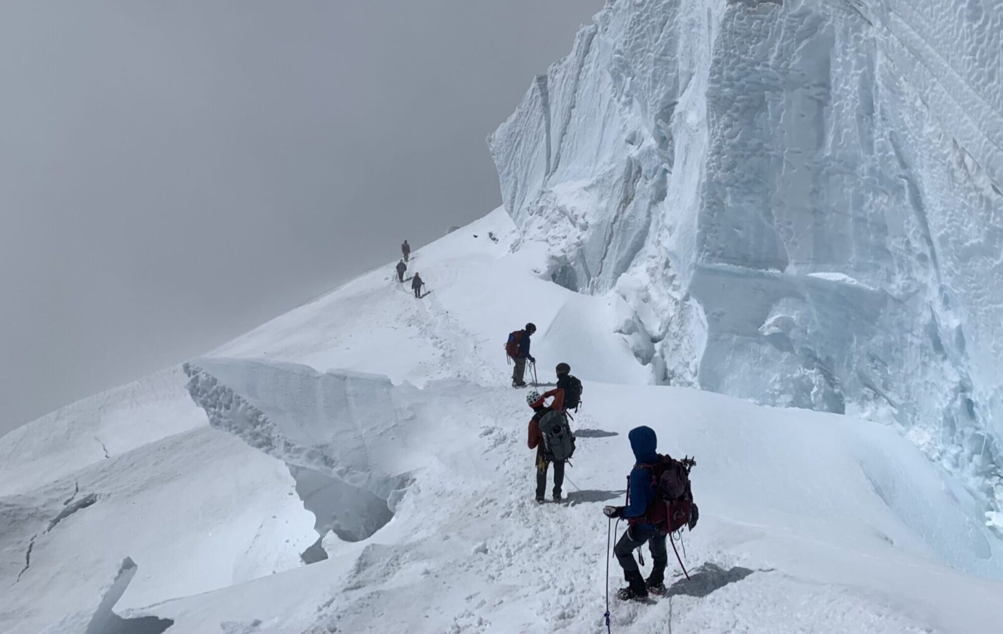
The plan for day 1 was to tackle the Crestones. There are 5 fourteeners in the Crestones: Crestone Peak, Crestone Needle, Kit Carson Peak, Challenger Point, and Humboldt Peak. According to elevation gain and length, this was going to be one of my easiest days. However, in terms of how technical the day was, this was going to be one of the more difficult, and I was glad to get it out of the way early. The climax of the day was to be the classic class 4 traverse between Crestone Peak and Crestone Needle. The traverse ends in a spectacular 40 feet of very exposed, steep climbing as you climb to the top of the needle.
I couldn’t sleep very well all night long, because I was so nervous. Around 3:40am I decided I had waited long enough and got up and started getting my stuff together. My original plan had been to try to carry a light pack but by the time I was finished packing my backpack felt heavy. I couldn’t find anything I wanted to leave behind, so I just took the heavy pack.
One major problem for me was that I did not have a 4 wheel drive vehicle. This presents a serious problem with several 14ers. My solution to the problem was to borrow a dirt bike from a friend of a friend that I knew from my days as a raft guide in Buena Vista, Colorado.
That morning, my friend Shane got up and was trying to get the motorcycle started. He walked out of the parking lot and down the road a little bit so he wouldn’t bother anyone who was sleeping. To our surprise, the motorcycle started right up, but quickly died as he tried to shift into first. Then it just wouldn’t start. Shane was trying for a least a half an hour with absolutely no luck, the motorcycle wouldn’t even try. I was trying to think of what I was going to do if it didn’t start. Basically I had the South Colony Road ahead of me, about 6 miles and 3000 feet, it was considered one of Colorado’s toughest 14er roads. If I had to walk it, it would probably only take about two and a half hours, but I was trying to save my body for the days ahead. Finally, I gave the motorcycle a try but had no better luck.
Shane decided to try to start it by coasting downhill and shifting it into gear. Shane started coasting downhill, waited until he got his speed up, then shifted it into gear, and the rear tire locked up and he skidded to a stop. He tried again…and success! The engine fired up and Shane shot down the hill. In a few minutes he returned to the parking lot where Natalie and I were waiting for him. At last, everything was ready.
I was very nervous as I got onto the bike. I had never ridden a dirt bike before, and here I was, about to do one of the toughest roads in Colorado in the dark, with a bike that I was not confident would start again if I stalled it out. I decided that I was not going to even try to shift gears, once the thing was in first gear, it was staying in first gear. Since I was so nervous I asked Shane to come and swap it out with my mountain bike while I was climbing so I could ride down the road on something more familiar.
I started up the road and my adrenaline shot sky high. Nothing on the road was super difficult but the difficulty rarely eases up. It turns out that dirt bikes like to go fast, and since I didn’t want to stall it out I wasn’t about to slow down. A couple of times I got out of control and ended up heading directly into a huge rock or rut, but I kept my speed up and couldn’t believe it as the bike just took the hits and kept on going. The story was the same at the two stream crossings, I cruised right on through the water. However, the bike kicked up a bunch of water and completely soaked my shoes and socks. I didn’t think about it at the time, but later my feet would be very unhappy. A couple of weeks before I thought it would be smart to toughen up my feet by hiking up Mt. Sanitas in Boulder barefoot. It was so hot that day that the entire balls of my feet blistered. By the end of this first day, no doubt accelerated by being wet from the stream crossing, I was able to pull off pretty much the blistered skin pretty much the entire ball of my foot on both feet.
I reached the South Colony Trailhead around 5:20am. I parked the bike, and got ready to go. At 5:30am sharp the official clock started as I headed up the trail on my way to Humboldt Peak.
Around 6:30am a beautiful sunrise cheered my spirits, while at the same time the ominous clouds covering the Crestone Needle made me fearful of what the weather gods might have in store for me. I quickly reached the summit of Humboldt, a relatively easy walk up. However, at the summit my altimeter informed me that I had only come up 2800 feet from the trailhead. So, not wanting to violate the 3000 foot rule, I hiked down until my altimeter said I was 200 feet below the summit, then hiked back up for an official summit time of 7:23 am. [In hindsight this was a silly thing to do. Barometric altimeters can be wildly affected by atmospheric changes in pressure] From the summit I radioed down and let Shane and Natalie know how I was doing. I had failed while trying earlier to radio them and it became clear that the radios would have very limited use, as contact could be reliably made only when I was on top of a mountain. I was planning on signing any summit registers I could find, as it would provide some sort of verification that I had reached a summit, but could not find one on Humboldt.
I was now concerned about the weather. East of the summit of Humboldt were nice clouds. West, where I was headed, was totally enshrouded in dark clouds. I continued over to Kit Carson. The hike to Kit Carson is a relatively easy class 2 walk until you reach the saddle between Kat Carson and point 13,790 (“Obstruction Peak”), where it becomes more difficult, especially since it was now sleeting. All of the rock was wet and in some places very slippery because of the lichens. I felt pretty confident and although the climb from the summit of Kat Carson (now called Columbia Point) to the saddle between Kit and Kat Carson is treacherous, I felt confident and had no trouble.
I made the summit of Kit Carson at 9:44am, but once again could not find a summit register. There was also no view, as everything was still fogged in and sleeting. On the summit of Kit Carson I had hope that the clouds would break because it was much brighter, but to my dismay the weather remained poor.
I carefully made my way over to Challenger Point and reached the top by 10:28am (once again I could find no summit register). Not everyone considers Challenger a separate mountain from Kit Carson because it is only .2 miles away, but since it rises 301 feet from its saddle with Kit Carson others do consider it a mountain. I figured that since it is right there I might as well do it.
I began my trek back toward Crestone Peak, very concerned about the Crestone Peak to Crestone Needle traverse, and about my ability to find the Northwest couloir when it is totally fogged in. Last year with my little brother Joe, we got lost and traversed across the entire Northwest Face while looking for the couloir, and that was when the weather was great. I crossed the Bear’s Playground and started across the Northwest Face, carefully following the cairns. Twenty minutes later I was lost. I couldn’t believe it, here I was being so careful and I got lost again. I looked around trying to identify a feature that I might be able to recognize in a picture in the guidebook. But it was just too fogged in, I couldn’t make out any significant features. Finally I made one of the most painful decisions a climber ever has to make: to backtrack. I backtracked and found where I had lost the trail and followed it even closer this time. Finally I found the entrance to the couloir, but I was surprised because I heard water, a lot of it, pouring down the couloir. I quickly found myself doing the most difficult climbing of the day, with water pouring over some of the best handholds. Once I climbed through the water and the first part of the couloir, I moved over to the right side of the gully and was able to stay out of the water. But the rocks were rotten and loose and everything was slick from the sleet.
I reached the top of Crestone Peak at 1:40pm. I figured that my little detour cost me about an hour, but was finally able to sign a summit register. At this time the foremost thing on my mind was the last part of the upcoming traverse, I was not happy that I would have to it when it was wet. Also, my left knee was starting to hurt because all of this technical scrambling was hurting my knee in a spot where I had been having some major problems in the last year.
I slowly made my way down from the summit of Crestone Peak as I began the traverse. My knee was very unhappy on the downhill, and I was feeling very sluggish and had a very bad altitude headache. To my happiness, the sun was beginning to break open the clouds, and the wind coming from the southwest would clear the clouds out as I was traversing. The rocks began to dry, so that by the time I was half way through the traverse I was able to get a solid grip on the rocks again. I had no problems on the traverse. Normally, it is a difficult route to find, but the year before I spent a couple of hours lost on the route and I remembered it well enough that I didn’t get lost on it this time. The final section that I was concerned about was as spectacular as I remembered it, and since the clouds had cleared away I had a great view, especially of the exposure to my left, 2000 feet straight down to South Colony Lake.
I made the summit of the Crestone Needle by 3:51pm. On the way down I had a very difficult time because my knee was hurting so bad. I could also feel some blisters on both feet, as hiking all day with wet feet was beginning to catch up with me. It took me about 3 hours to get back down to the trailhead, as I had to go very slow. I began wondering how I was ever going to go on if my body was hurting so badly after the first day. Fortunately, the last half mile is fairly flat and was much less painful. There was still hope that I might finish.
When I got to the trailhead I hopped on my mountain bike and cruised down the bumpy road and got to the parking lot at about 7:30pm, where I laid down, happy to be finished. The road was so bumpy coming down that I was thinking the mountain bike may have been a mistake, but at least it was fast.
Good news from Natalie was that I had been granted permission to climb Culebra at 5:00pm the next day. 5:00pm? How the hell was I going to make it to Culebra by then. I had four mountains to climb before that, and wasn’t sure I could do it, but nevertheless it was still good news that I had been given permission to climb the mountain. It had recently been totally shut off to climbers, and I had made several calls to try to secure permission to climb the mountain.
Bad news from Shane was that on the way down he had broken the clutch cable on the motorcycle. Especially bad news because I needed the motorcycle in the morning to get up the Lake Como road to Blanca Peak, the toughest road in Colorado.
After a great deal of thought and worry, I decided to change my plan for the next day, and do the reverse of what I had originally planned. That meant we needed to get to the trailhead for Mt. Lindsey and I needed an early start, we were going to shoot for about 3:00am. I went to sleep in our Volkswagon Vanagon, snuggling the Mouser (my cat), while Shane and Natalie drove the cars to the bottom of the Huerfano River Trailhead road.