Day 2, June 19, 2014
Handies: Stuck on a headwall, and the San Juan Ron Mobile.
Because I was a little behind schedule, and it was already light, I was reconsidering my decision to skip a gnarly shortcut to get to Cinnamon Pass. Just as Ophir Pass was critical to Day 1, Cinnamon Pass was critical to day 2. It is the most efficient way to get from Ouray to Handies Peak, the peak I wanted to climb after Sneffels. Cinnamon Pass itself is a little more difficult than Ophir Pass, but it was nothing for the dirt bike.
From where we were parked, I had two options. One was to get in the car and rest for about 30-40 minutes while James drove us to Silverton. From Silverton I could ride some relatively easy dirt roads on the dirt bike to the start of Cinnamon Pass. The other option was to stay on the dirt bike and take a much shorter road that left the highway just a couple of miles from our current position and headed directly towards Cinnamon Pass and Engineer Pass, that cuts off around 75% of the distance. I am not sure what the road is called but I think it follows Mineral Creek. During scouting I had driven down and up it again, the up during a lightning storm, and it had thoroughly intimidated me. I had crashed twice, and almost driven off the edge of the shelf road to my doom. I figured since I thought it would be dark that it wouldn’t be worth the risk.
However, I was concerned about running behind and since it was light I saw the shortcut as a good opportunity to gain 30 minutes to an hour and almost put me back on schedule. So I was kind of leaning towards the aggressive option, but James managed to talk me out of it. So I ate and drank a few mouthfuls and climbed into the back of the pathfinder to try to get a few minutes of sleep on the way to Silverton. We left Ouray at 5:30 am, exactly 1:30 behind schedule. It was a little hard to get to sleep in the pathfinder, because the bed was a little cramped. However I must have fallen asleep for a little while, because in what seemed like no time at all, we were in Silverton.
I expected the car to stop at any moment, because then I would jump out, hop on the motorcycle and head to Cinnamon Pass as quickly as I could on the dirt bike. But James didn’t stop, he continued driving along the dirt road towards Cinnamon Pass. I remembered an ATV staging area, and thought maybe he was going to stop there. He was driving really fast, I was getting bounced around hard, and I could see the dirt bike bouncing around hard on the rack on the back of the pathfinder.
I was actually pretty annoyed. I just felt like it was risky to drive so fast. That was the whole purpose of the dirt bike – I could drive fast to gain time, but the support crew could theoretically take it easy and not risk damage to the vehicles. Will and Kim had driven around the long way and avoided Cinnamon Pass. We were on our own for the time being and any mechanical issue with the car could be a serious problem. It was not like I was getting any good rest either, I was getting bounced around and boxes and gear were falling on me.
Finally, I voiced my concern. James had a plan so I didn’t argue. But I was relieved when we finally arrived at the location James had picked for me to start dirt biking. We certainly hadn’t lost much time. James was driving almost as fast as I would have gone on the dirt bike. But I wished I hadn’t spent the last 20 minutes completely stressed out!
James prepped the dirt bike, and warned me to watch for ice at stream crossings, and I headed up the road. It was a beautiful morning with blue skies. The dirt bike made quick work of the west side of the pass. But once descending the east side I found that the snow banks were melting and water was all over the road, and most of that water was still frozen. James had been right to warn me to watch out for the ice! I took it a little slower than I wanted because of the ice, but continued down much quicker than we could have in a 4 wheel drive.
At the base of Cinnamon pass, rather than turning right and heading up in American Basin to climb Handies, I had to go left (for quite a distance!) to satisfy the 3000 foot rule. During scouting we had marked the exact bush on the side of the road that I needed to park at, so I didn’t have to waste time finding the right spot.
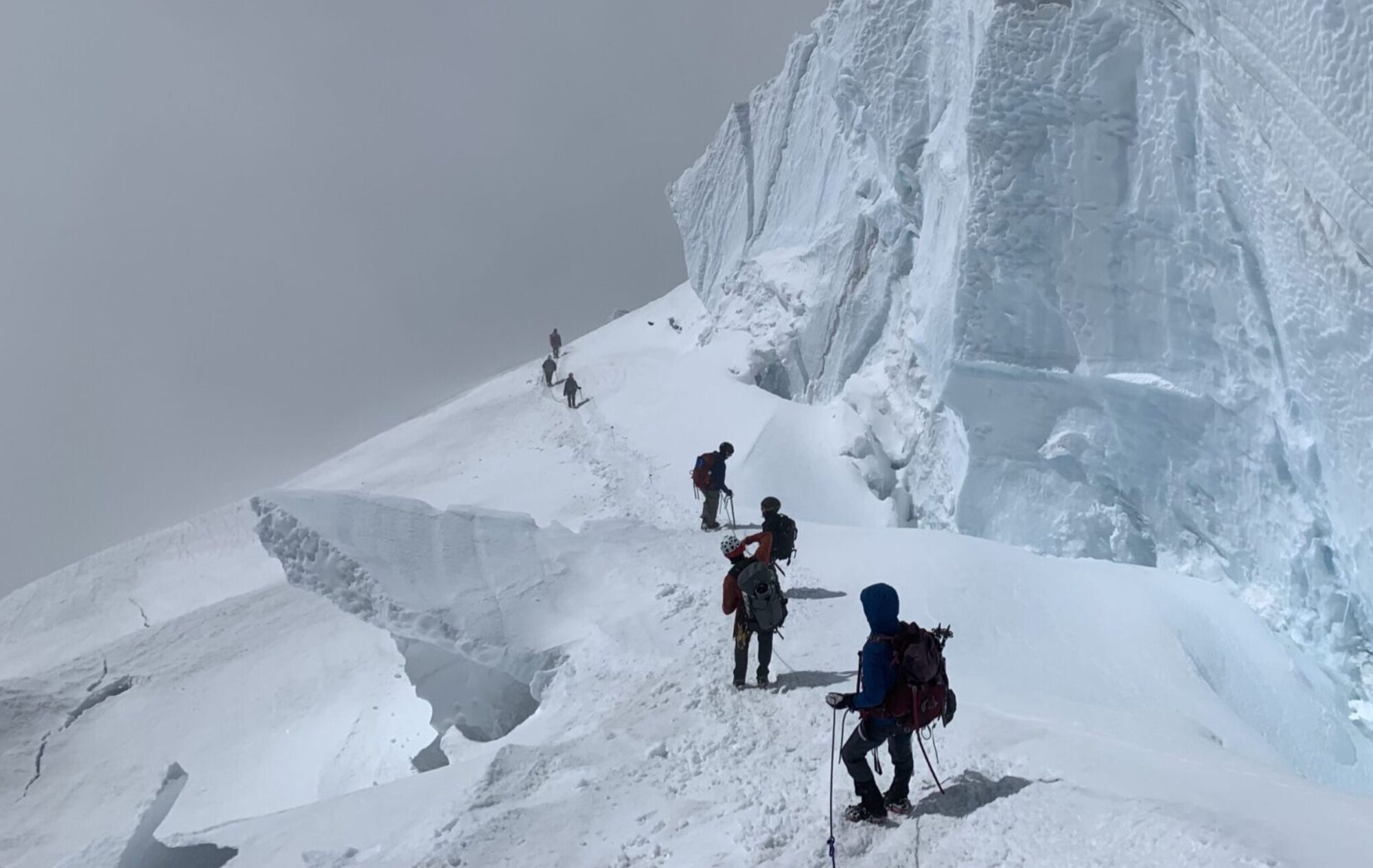
I left the dirt bike and started walking up the trail at 7:11 am. On the scouting trip, we had found Handies covered in snow, and I had decided to forget about the standard route and take a more direct route to the summit. We had seen a good looking snow couloir that topped out right near the summit ridge, and I had brought crampons so that I could walk directly up the couloir. I looked for this couloir and once I recognized it (it had kind of a bow shape with a couple of “H” shaped snowfields nearby) I put on my crampons and headed up.
The sun was up, but as I was on the west side of the mountain I was still in the shade and the snow was still bulletproof. After trudging up the couloir for several hundred feet, it started to get steep. Usually I am fine with my trekking poles and crampons while heading up snowfields, and I made the mistake of not pulling out my ice ax. I continued with the poles despite it getting steeper and steeper, and was able to make some use of some exposed rocks. Where the rocks ended, there was only about 10 feet left to go before the steep headwall relented and the grade eased. I made it a few steps up and found myself completely stuck. The snow was so hard that my feet were only hanging in by the toe points on the crampons. Even if I kicked I couldn’t get a step to rest my foot on. The snow was so steep that I found my poles to be useless.
I looked down because I wanted to descend to one of the rocks so that I could take off my pack and get my ice ax. However, my position was so precarious that I didn’t dare go back down. And I couldn’t get comfortable to take another step up. The snow was so hard and there was nothing to hold on to. I was stuck and I wasn’t sure what to do. Without decent handholds I felt like I was going to fall backwards, and I was disgusted with myself, why didn’t I have my ice ax out on this terrain! I think I had just figured that with crampons on I wouldn’t run into any trouble, this really caught me by surprise.
The only option I liked was to go up and over the steep part, and I still had about 5 feet to go. It took a long time, but I found a solution. I needed steps, and I just had to stand in place, and kick, and kick, and kick until I had created a step large enough to provide some support. I repeated this process and slowly made my way up and over the headwall.
I was now feeling mentally a bit depressed and tired. I had been hoping for a lightning fast ascent on Handies and this silly error had cost me some time. In my melancholy mood I continued slowly up to the summit ridge and up the last few hundred feet to the summit, which I reached at 9:16 am.
For the descent there was no way I was going to try to go down the same couloir I came up, but the next snowfield to the south looked reasonable so I descended to it to give it a try. Unfortunately, even in the sun it was still just too hard for a comfortable glissade. Determined to save some wear and tear on my legs, I pulled out my sled and slowly and carefully glissaded down while in self-arrest position.
I know I have mentioned glissading in self-arrest position already. It is not the most desirable way to glissade! First of all, you have to be careful that the ice ax does not get ripped out of your hands. If you happen to pick up any speed, and the point of the ax contacts either a rock, or patch of ice, or even just harder snow, then it is very easy to lose your grip on the ax, and then you are pretty much screwed. It takes a lot of upper body strength to maintain the necessary grip on the ax. You also don’t have a great view of where you are going, and you lose most of your ability to steer. So it is not my favorite way to glissade. However, when the snow is super hard it is the only way I can manage to keep myself comfortable in control.
I was determined to stay in the snow and had to crossover to another gully to avoid cliffs several hundred feet down, but the glissade was slow and difficult all the way down. It was probably not faster than just running down the side of the mountain, where most of the snow could have been avoided.
Near the bottom I did finally get to a place where the steep angle of the hillside relented, and I was able to relax and enjoy a fun glissade for the last couple of hundred yards down to the main trail.
The best word to describe me at this point in time was “weary”. I was tired, I was walking slow and feeling a little sorry that Handies had beaten up my spirit. I crossed the raging stream by walking over the snow, and began the hike down to the dirt bike. Up ahead some people stopped in a dune buggy looking contraption, and as I walked toward closer I recognized Kim and James. My spirits immediately rose. It is hard to describe the emotional lift you get from just having some company on a multiday adventure like the 14er record. I immediately perked up and told them about my troubles in the couloir, and the 3 of us walked down the road towards the dirt bike.
The dune buggy looking contraption, which I have since named the San Juan Ron mobile, was driven by San Juan Ron, a fellow 14ers.com member who had heard about our plans and driven out to cheer us on. He had even written “Go Andrew” on a cardboard sign he had in the back of the vehicle. He had driven James and Kim up to meet me from my next trailhead, and once I had descended enough to satisfy the 3000 foot rule he intended to give me a short drive down to the next trailhead, the Silver Creek/Grizzly Gulch trailhead that is the start for Redcloud and Sunshine. I was back down to the dirt bike by 10:25. Somehow through all that I was maintaining my 1:30 deficit on my ideal schedule and not falling further behind schedule.
It was fun to have a spectator, and I was impressed with his driving on the 4wd road. Since I was getting a lift, James took the dirt bike, and I was amazed that San Juan Ron actually didn’t lose much time to the dirt bike. San Juan Ron told me he had a cabin nearby, and that Axel was off learning to fish with Will on his property.
We reached the trailhead at 10:40 am, I thanked Ron and stopped for a picture, then sat down for a quick rest and some food as we all prepped for the next mountains. The sun was beating down and for just about the first time since the start I was hot.
Redcloud and Sunshine
What was great about James was that from the beginning of the record, he completely understood how every minute saved was critical to the overall record. He was constantly thinking of ways to save a few minutes here and a few minutes there. Without him I think the whole thing would have fallen apart pretty quickly during those first couple of days.
He also understood the importance of utilizing others to save wear and tear on my body, and he had recruited Andrea, Kim, and Calvin to hike with me and carry my pack up to 11,000 feet. I had kind of a slow transition as I ate, changed my socks and figured out what shoes to wear. After my emotional up and down on Handies I needed a little break to recover my will to go on.
Finally we started up the trail at 10:56 am. It was nice to have the company, and I led our little group up the trail. All too soon the GPS closed in on 3000 feet, so I took my pack and my Hoka’s (extra shoes for the run down the trail) and said goodbye to the others. Then I turned on continued on alone up the trail. I was hoping for a nice glissade off the west side of Redcloud. Since it was going to be right in the middle of the day when I would begin my descent, I knew the snow would be soft and I was looking forward to a fun descent. So that meant I would ascend Sunshine first. At a river crossing where you turn south into an enchanted forest, I left an extra Gatorade and my running shoes for the descent, and crossed the raging stream on a log bridge that James, Andrea, and I had constructed the week before on our scouting trip. Immediately I encountered soft snow in the trees. But I was able to get out of the forest into the open by staying on the snowpack that had formed over the stream in the gulch. The snow in the trees was much softer than the big snowfields so it was best to avoid the trees.
Eventually I was able to find and follow the trail again, but soon I ascended above treeline and was able to stay on snowfields instead of the unpleasant fields of talus while down in the basin. Soon I turned east and ascended a snowfield that helped me attain the lowpoint on the ridge between Redcloud and Sunshine. The snow was steep, and ended in a very unpleasantly steep, loose and rocky slope that lasted for a few hundred feet. At the saddle there was a sign that asks people not to use the route I had chosen, however as a snow climb it is a pretty direct way to climb Sunshine.
Once on the ridge, I left my pack and headed up the remaining 500 feet to the summit of Sunshine, and reached the summit at 1:19 pm. Even the ridge contained lots of snow, and this snow had been in the sun all day and was now very soft. So I avoided it as much as possible to avoid postholing.
I made the summit, immediately sent out the satellite message, and turned around to pick up my pack and complete the traverse to Redcloud. The traverse went by pretty fast and before long, after bypassing one depressing, but expected false summit I was on the summit of Redcloud (summited at 1:58 pm). I had a great view of my next set of mountains, Uncompahgre and Wetterhorn, and was discouraged by the amount of snow I could still see up there. It seems like this was a strange year. Supposedly the San Juans had a low snowpack this year, at about 60%. And down at lower elevations I sure did not see much snow. But up above 12,000 feet there was seemingly a crazy amount of snow this year.
I began descending Redcloud via its standard route. But soon turned to the west and began descending some unpleasant scree so I good find the snowfield I wanted to descend. Unfortunately I had to descend the rocks much further than during the scouting trip, as there had been a fair amount of melting on the west facing slopes.
I wondered if people that were following along via the satellite tracker would notice when I glissaded. Relatively speaking I am pretty slow for someone trying to set the 14er record, especially on downhills. On downhills where others can run pretty fast I usually limp and hop and moan and groan as I try to manage knee and ankle pain. However, I was also the first that I know of to try to set the record with so much snow still in the mountains. The one good thing about all the snow was that it meant there would be lots of opportunities to slide down the snow, and in the right conditions that can make for a superfast descent.
Once I finally made it down to the snowfield, I discovered that the snow was very soft, and it wasn’t quite steep enough at first. Finally I did get moving, and it was a very fun glissade. It was one of the few big glissades that was at a steep enough angle to get moving fast, but not steep enough to be scary. It was pure fun, except that it had melted out with lots of runnels and bumps and mounds. I began to notice that my butt was pretty sore from all the glissading and dirt biking. Still, I was able to glissade all the way down and even cross the tracks I had left in the snow that morning. The only bad news was that I lost one of my poles on the descent, and there was no way I was going back up to find it! Two days, and two of my four poles lost. I was a little nervous because I simply do not hike well at all without my poles…
I retraced my earlier steps down to the river crossing, and changed out of my Speedcross shoes into the Hoka’s. The Speedcross shoes had been invaluable waterproof shoes with their good traction in snow, but my right foot had developed a bruise on top of the foot from the shoes, and soon I wouldn’t be able to wear the right shoe anymore. Once again changing into the Hoka’s felt extremely luxurious, and I looked forward to using them again. It was very warm now, and I was tired and desperately wanted a nap, so I was looking forward to the 40 minute drive to Nellie Creek trailhead.
I jogged my slow, haggard looking jog as much as possible down the trail. I was secretly hoping that someone would be waiting to hike with me from 11,000 feet down to the trailhead, but unfortunately I hadn’t thought of that so I was on my own all the way to the trailhead. They saw me coming and Calvin came running out to greet me while Kim danced to some motivational music playing from one of the cars. At 3:18 pm I sat down by my gear that James had laid out, and stuffed down some food, protein shakes, and liquids. I was starting to lose my taste for solid foods and for the protein shakes. This was expected and James was very good at convincing me to take more bites even when I felt like I couldn’t stomach anything else.
At this point Kim and Andrea didn’t really know how to step in and help out, and I realized how lucky I was that I had James who really understood what was needed right from the start. Later we would become a much more efficient crew and everyone would figure out their part on the team.
Uncompahgre and Wetterhorn: Saved by Snowshoes, and a Bright Headlamp
After I drank and ate as much as possible, I climbed into the pathfinder, and stretched out as much as possible. While the others packed up, I tried to sleep. Soon James got in the car and we started driving. The drive out to Lake City is relatively smooth, so I was optimistic to get a little bit of sleep. However, somehow James and I started talking upcoming strategy, and before long he was talking and talking and talking and I kind of hoped he would just be quiet so I could get some sleep. I couldn’t help but tune him out and just agreed with everything he said, but inside I was lamenting every minute that passed.
Unfortunately, we arrived at the turn off to Nellie Creek and I still hadn’t fallen asleep. It was just James and I as everyone else was supposed to go into Lake City, get some food, and meet up with my mom who was arriving with the Van. I knew now that I was a little behind schedule that I would not be able to achieve my optimal Plan A and make it to Culebra the next day, and since I bought a pass for both Friday and Saturday, Kim, Andrea, and Calvin were going to head out and climb Culebra the following morning. It would be Kim’s last 14er.
James prepped the dirt bike while I tried to get my gear together. I had to make a call on whether to bring snowshoes. In scouting we had found there to be a tremendous amount of snow on Uncompahgre and Wetterhorn, and from Redcloud and Sunshine earlier I had seen that there was still a large amount of snow. However, my snowshoes were heavy and I was having a tough time deciding if I wanted to bring them. It was late in the day and I didn’t want to get caught in miles and miles of mushy snow, but on the other hand in something like this you always want to travel as light as possible, and usually if you get to the middle of the snowfields away from the rocks then you won’t fall through and have to posthole.
Finally I decided to leave the snowshoes behind. Then James talked me around and convinced me to take them. So I pulled out my larger Salomon pack and packed it up with the snowshoes, food, headlamp, and everything else needed. My plan called for hike to take about 6 hours, however that was for normal conditions. I had no idea how much the snow would slow me down. I was looking forward to a couple of nice descents, so I thought maybe that would make up for the lost time. I ate some more food including another protein shake. It was only day two and I was getting very sick of those protein shakes!
I was extremely nervous about the upcoming dirt bike ride. About half way to the Upper Nellie Creek Trailhead there is a river crossing, and during our scouting trip it was pretty high. In fact I had heard it was running higher for this time of year that it had been since the 1990s! I had taken one look at it and chickened out and turned around. While I was scouting Wetterhorn with Andrea, James took the bike up to the river crossing and even he had run into some trouble. The river crossing was tricky because it starts out in flat water, but then you have to turn left right into the thick of the current, and right where it is deepest there are some boulders that are large enough to knock you over if you aren’t careful. In the end we decided it would be safest if I just walked the dirt bike through, and I had practiced this so that I would feel confident when I tried it during the record attempt. The one thing I had to avoid was either crashing or dropping the dirt bike in the water. A dirt bike can recover from going under water but you have to know what you are doing…And as I think I have made clear, when it comes to dirt bikes I am definitely a novice!
At 4:40 pm James had the dirt bike ready, so I put on my dirt biking gear and pack, and headed up the trail. I did have some backup in that James would be hiking up the road to pick up the dirt bike where I would drop it off at about 11,300 feet, 3000 feet below the summit of Uncompahgre. The adrenaline from the dirt bike and my fear of the upcoming river crossing had me wide awake. I was psyching myself up and I convinced myself that the stream would be lower than it was during the scouting trip. I would just go for it and zoom through the river crossing. I didn’t have any trouble with the steep, rocky road leading to the crossing, and felt pretty confident. As I descended down to the crossing and rounded a corner, so I could see the crossing, I was surprised that it didn’t seem any lower than during the scouting trip. If anything it seemed a little higher, and just as I reached the water my confidence left me like air leaving a popped balloon. I dismounted and prepared to walk the bike through the crossing.
The dirt bike, a Yamaha wr450, was just too big for me to push around. So when I say I have to walk it through the stream, I am really walking next to it, but giving it gas and just keeping it balanced as it goes over the rocks. Well, that is the idea. In reality I had a tendency to stall it out, because I didn’t want to give it too much gas and have it lurch away from me. I slowly moved into the water, and felt the icy grip of the water on my legs. I walked the bike through the flat water, and then right as I eased it up over a boulder and into the meat of the current, I accidentally gave the bike too much gas and it lurched forward and I stalled it out. Fortunately, I was able to keep it upright, but it wasn’t easy as because the current was strong.
Then I ran into some trouble, the bike wouldn’t start up again! The battery, despite all the driving I had been doing was just not strong enough and after a minute of trying I could hear the battery giving up on life. I tried but couldn’t push the bike forward because of all the big boulders, then I tried yanking and pulling the bike back the way I had come but managed to wedge myself in worse than before. Meanwhile my legs were starting to get numb. All the water in this creek was snow earlier in the day and it was cold!
I momentarily thought about abandoning the bike in the middle of the crossing. Eventually James would find it and deal with it. But then I would have to hike for an extra couple miles up the road. Or I could hike down to him, and he could run down to the pathfinder and drive me back up the road. Either way it was a disasterous loss of time. I was only going to save 20 minutes or so by using the dirt bike, and now I could lose an hour! Again I tried yanking the bike backwards, but couldn’t budge the bike. I sure wish I had considered a smaller bike like a 250 that I would have been able to push around a little easier.
I still hadn’t decided what to do, but I tried starting the bike again, after a couple of lugs it miraculously started up. I was back in action! But I could take no chances. I knew I could not be timid because I had no reason to believe I could count on the engine starting up again if I stalled it out. So I pulled back hard on the gas, and the bike shot forward like a missile. I wish I had a video of this, because it must have been pretty funny to see me get yanked off my feet, into what felt like “Superman” position, barely hanging onto the handles with my body flying through the air. The bike bounced over a couple of boulders, made it across the stream, then I swerved left and then overcorrected and crashed hard to the right. I didn’t know it until later but I broke the rear brake pedal on this crash. The engine did not shut off as the rear wheel was spinning in the air, and I immediately wrestled the bike up again.
Somehow I was across the raging stream, and I felt exhausted but exhilarated! I started up the road again and with a fresh batch of adrenaline flowing through my blood I continued up the road. I was relieved that the dreaded river crossing was done.
The GPS was lagging a bit because I was driving so fast, and I overshot the elevation I needed to park at. It took a few minutes to find the correct spot. After I finally parked, I changed out of all of my wet clothes and shoes and left them to dry on the bike. One nice side effect of standing in the water so long was that it was kind of like icing my legs, and they felt refreshed.
I started up the road at 5:20 pm. It was only a few hundred feet to get to the Upper trailhead (I couldn’t go all the way up because of the 3000 foot rule). It was obvious that much snow had melted in the last couple of weeks, especially below treeline, so I made very good time hiking up the trail.
After I passed treeline, I had to navigate an extremely steep snow headwall that blocked the trail. Once I passed the headwall, I found the trail again and only had a short time on the trail before it disappeared below the sea of white. Interestingly, I could see that much of the snow was shallow, and the shallow snow was very soft, and offered no support at all so I would fall right through. I was at a place where I had to decide between trying to stay with the trail, which took a circuitous route to the summit, or just heading straight to the summit. In the summer there is an area that hikers are asked to avoid to save fragile alpine species, but with the snow I didn’t have to worry about that, so I chose to head straight ahead on the most direct route to the summit, which appeared to be almost entirely on snow.
With some careful zigzagging, I spent as little time in the soft snow as possible. In places it was easy to spot because instead of a flat surface, or uniform bumpy surface, it was usually given away by its irregular bumpy look. So, despite a fair amount of soft snow I never felt the need to actually put on my snowshoes. There was one area where I thought I was on nice consolidated snow, because it was totally smooth and I was not sinking in at all. I was just innocently walking along when all of a sudden I stepped into a mysterious patch of soft snow and fell in all the way to my waist. For some reason, there was an “island” of soft snow ahead of me. It reminded me of what quicksand might be like in the jungle. I turned around and once I climbed back on the solid snow, I used my poles like a blind person might use a stick, to poke at the snow and find the edge between the soft and consolidated snow. In this manner I was able to make my way around that patch of snow.
I crossed some old avalanche debris that was melted into some interested ice formations, and made my way up to the southern ridge of Uncompahgre. The wind was blowing and I quickly became chilled so I had to stop and put on my wind jacket. I continued over to the west side of the ridge, where there was less snow, and followed it up to the summit, it was 7:25 pm.
As usual, I didn’t spend any time on the summit, just enough to send my satellite message, then I immediately backtracked and headed back down to find the southwest slopes route, the most direct route to get to Wetterhorn. I had been looking forward to the upcoming 2000 foot snow descent in the soft afternoon snow. I had to descend about 100 feet of unpleasant loose rocks to get to the top of the snow. But once I retrieved my sled and ax from my pack the snow did not disappoint. It was a beautiful, fun, fast descent on perfect snow. The only downside was that the snow was so wet, that I was soaked by the time I was half way down. Despite the good snow conditions, my upper body was weak and controlling my speed with my ice ax was difficult and fatiguing, so I had to take a few short breaks. Near the bottom of the snow field, the snow was too mushy to glissade, so I left the snow and followed some grassy slopes and continued towards Wetterhorn. Soon the grassy slopes ended and I was forced to climb back up onto the snow. The snow was so soft and deep that I couldn’t make any progress. I was in deeper than my waist and the only way through was to make a trench.
I figured it was finally time to put on the snowshoes. With them I was able to get through the soft snow up to where it was packed more firmly. Then I continued across the snow to the pass between Uncompahgre and Wetterhorn. Much of the snow was shallow and soft, and even with the snowshoes on I still fell through the snow in several places. I probably would have been OK without the snowshoes in the end, but I do think they saved a fair amount of work.
The sun was just starting to go down as I passed a 13er called Matterhorn that sits between Uncompahgre and Wetterhorn. I finally came to a rise where I could see the rest of the route up Wetterhorn, and I was disappointed! I had been hoping to just leave the snowshoes on all the way up to the south ridge of Wetterhorn. Unfortunately enough snow had melted that there was an even mix of talus fields and snow fields. I certainly did not want to keep changing in and out of snowshoes, but as the shadows pushed away the sunlight with the setting of the sun, I knew the snow would get hard fast. So as I reached the base of the talus fields I decided to take off the snowshoes and leave them behind as I could retrieve them on the way back.
The light started getting dark as I alternated hiking on rocks, sometimes on the trail, to losing the trail in snow and then trying to regain the trail when I made it across the snow. In this manner I continued hiking until gaining the south ridge of Wetterhorn at about 13,000 feet. The wind was blowing fast up and over the ridge and it was now pretty cold. I drank the last of my water and powder, and left my pack and poles behind and continued up the ridge with my ice ax in hand. Even the wind blasted ridge was not free of snow, and in the darkness I had a little bit of trouble locating the trail. I made what turned out to be a good decision and when the trail started contouring on the west side of the ridge, I left the trail and headed back to the top of the ridge. I could tell, even in the darkness, that the standard route was going to be covered with snow and I knew the trail would be difficult to follow. At least up on the ridge the routefinding would be easier, although you still have to navigate some large boulders and small cliffs to keep the difficulty around class 3.
I didn’t run into any trouble on the way up and soon made it up to a large prow like formation near the summit block. I think Wetterhorn is the quintessential class 3 peak in the state (along with Long’s). If you want to show someone what it means to be class 3, then Wetterhorn is a great example of that. The last 150 foot pitch up to the summit is normally a very enjoyable climb, although it is quite exposed. Fortunately this pitch was completely dry. So I left my ice ax behind at a notch, and continued up to the summit. I don’t remember having any trouble on the way up, and I made it to the top and sent my satellite message at 10:00 pm.
Suddenly I started to feel a little tired and I wasn’t thinking very clearly. In this foggy mental state I began the downclimb, back to the notch where I had left the ice ax. In the light it is pretty easy to find where to exit the class 3 ledges. However, in the dark and cold wind I became confused and thought I had overshot the exit. So I climbed back up until I realized I was just below the summit again, so I headed down again. Finally I found the correct exit, and made it around the corner to pick up my ice ax and begin descending.
Back in 1999, I had also been climbing Wetterhorn in the dark, although that time it was during a whiteout. Somehow instead of heading down the south ridge I had made a big error and taken the East Ridge toward Matterhorn. In more recent climbs of Wetterhorn I couldn’t believe how foolish I had been to make that error. However, I almost made the mistake again! I am not sure how this happened, because in the light the route seems completely obvious. I think I was only saved because after my debacle descending the Wilson’s in the dark the previous night I had asked the support crew to change the batteries in my headlamp. Those batteries must have really been week the day before because now the light was working great. This time I had not ventured along the ridge to Matterhorn, but had somehow wandered down a rocky rib that was heading west. I only realized the mistake because the bright light showed that there was a well-defined ridge way off to my left, and I knew that should not have been the case. So I backtracked to the South Ridge of Wetterhorn, and continued descending. I took it slowly to make sure I did not make another error. Wetterhorn is class 3 but as with just about any mountain if you lose your route there is usually much more difficult terrain around the corner.
The near mistake injected me with some adrenaline and that managed to pull me out of my drunken like mental state. I descended back down to the trail, crossed some now very hard snow on the ridge and made it back to my poles and pack. I tried to slide down a few snowfields on my way back down to the snowshoes but didn’t have much luck. The snow was too hard now and it just didn’t feel efficient so I gave up on the idea.
I made it back down to the snowshoes again, but decided to put them in my pack because the snow was firming up. Then I headed in a south west direction until I crossed a large ravine and eventually found the trail heading down to the Matterhorn Trailhead. If all went as planned, James would have picked the dirt bike up at the Nellie Creek Trailhead and driven it up to the Matterhorn Creek Trailhead.
Once down to treeline the trail was mostly clear of snow so I made good time and even tried to run a little bit to make up some time. The snow conditions had definitely slowed me down and I knew I was running a couple of hours behind schedule.
When I made it down to the trailhead at 11:49 pm I was relieved to see the dirt bike waiting for me, along with a protein shake. The dirt bike was cold and as usual, it refused to start, even with several attempts to kick start it. The good news was that I was parked at the top of a hill, so I wrested the bike into position and started coasting down the hill. Unfortunately, without any power the motorcycle headlights were not on, I hadn’t noticed all of the loose, large, rocks in the rutted four wheel drive road and somehow kept the bike upright as I was bounced all over in the dark. By the time I managed to gain enough speed to release the clutch, the engine started right up, and the lights came on for just a second, just long enough for me to see what I was about to crash into. Then the engine died, and I crashed, and I just laid there cursing myself for being such a terrible dirtbiker.
I had better luck on my second attempt as I gave the dirt bike more gas once the engine started up, and with the headlights blazing I cruised down the road without crashing again.
Just after midnight, at the bottom of the Matterhorn Creek road I found the Pathfinder and the Eurovan waiting for me, and I was relieved to see that my mom had found us. I was also excited to get in the van, which has a pretty nice bed, and get some good sleep. Mom, James, and Axel woke up (the others were climbing Culebra this morning and were already gone) and started helping me out. After greeting my mom and dropping most of my gear, I got into the back of the van. There was some cold pizza waiting for me which tasted pretty good, so I was willing to forego closing my eyes right away to force the food down. I was pretty disappointed with the organizational status of the van. Boxes were piled up all over, sleeping bags were scattered, and the pizza was tenuously balanced on a box and I could foresee it falling all over the place. I spent some time talking to my Mom and Axel as she followed James down the road, but I soon closed my eyes and was soon asleep for the 2 hour drive to Creede. We were still running about 2 hours behind schedule.